Kufr Malek to Al-’Auja

Experience one of the most stunning valleys in the area and admire its natural richness.
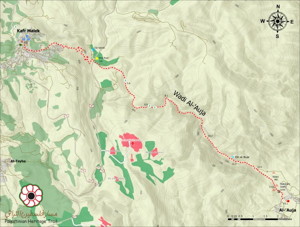
Following a small road from Kufr Malek, the trail zigzags down a hillside riddled with the remains of Roman cisterns and graves on its way to the Ein Samia Valley. After reaching the valley, the trail crosses a larger paved road and continues past fields of zaatar before following a path out of the valley bottom past the remains of an old Byzantine-era church.
After crossing a ridge, the path drops down into Wadi al-’Auja, a deep, rugged wadi that runs from Ein Samia (Samia Spring) down to Ein al-’Auja (Al-’Auja Spring) in the Jordan Valley. Wadi Al-Auja is home to an impressive array of plant life as it descends from the higher elevations of the Palestinian highlands to a point around 50m below sea level at Ein al-Auja, a popular, local picnic spot.
From Ein Al-Auja, the trail follows the wadi and ancient Roman aqueducts, used divert water from Ein al-Auja to Jericho, past the ruins of a Byzantine church, and onto the Al-Auja Bedouin community.
For the hike take:
- at least 3 liters of water
- snack
Kafr Malek can be reached from Ramallah or Nablus with a shared taxi for around 24 NIS.
Check the weather before you go. Always remember about sun protection (sunscreen, hat, sunglasses). During the summer season wear light but modest clothes. During the winter season remember about a warmer jacket – mornings and evenings are usually cold.
-
Topo map
-
Map legend
-
Walking notes
-
Elevation profile
-
GPX File


